
Global Coverage
Official Regional Map Grids
Works with government coordinate grids across UAE, Qatar, Pakistan, Saudi Arabia, the UK, and 5,800+ other coordinate systems worldwide.
5,800+ coordinate systems worldwide · select a grid for details
Save as KML, KMZ and DXF with site photos and comprehensive reports
Open your Excel or CSV coordinates on any grid and get a file that opens straight in Google Earth — points, boundaries and elevations in seconds, no GIS software needed.
Inspect satellite mapping, review spreadsheet point conversion, and check site calibration accuracy before exporting to KML.
Placemarks carry real heights (relativeToGround) for 3D extrusion in Google Earth.
Convert field measurements from your total station or GPS rover into accurate, client-ready 3D models with zero guesswork.
Works with government coordinate grids across UAE, Qatar, Pakistan, Saudi Arabia, the UK, and 5,800+ other coordinate systems worldwide.
Pins sit on Google Earth's terrain with each point's measured level in its balloon, plus level profiles and checks that catch a level that jumps.
Paste rows from Excel or open CSV files from Leica, Trimble, Topcon, or Sokkia. Auto-detects Point ID, Easting, Northing, and Elevation.
Aligns local site coordinates with official control benchmarks, adjusting for scale and angle rotation with under 1 mm accuracy.
Connects survey points to draw property perimeter lines. Calculates boundary fence length and land area in square metres and hectares.
Links field photos to survey marks. Photos pack inside the file so clients click any pin in Google Earth to view the real site photo.
Three simple steps to transform coordinate tables into georeferenced Google Earth deliverables — no complex GIS setup required.
Paste rows directly from Excel or drag-and-drop raw CSV files. Auto-identifies Point ID, Easting, Northing, and Elevation columns.
Select country or EPSG coordinate system — Dubai DLTM, Qatar QNG, Pakistan UTM, or UK Grid. Datum shifts calculate automatically.
Save a KML or KMZ with your points, boundary lines and photo balloons. Opens straight in Google Earth and GIS software.
App tutorial
Four steps from your survey sheet to Google Earth — with screenshots of the real app.
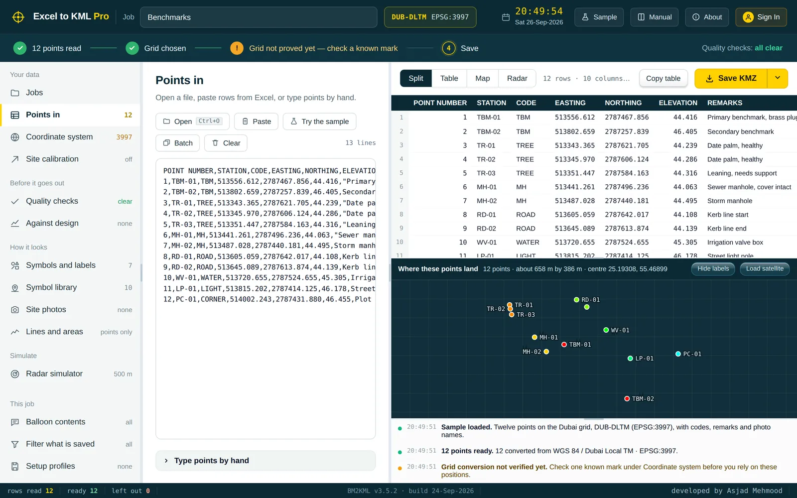
Step 1
Open an Excel or CSV file, paste rows from Excel, or type points by hand.
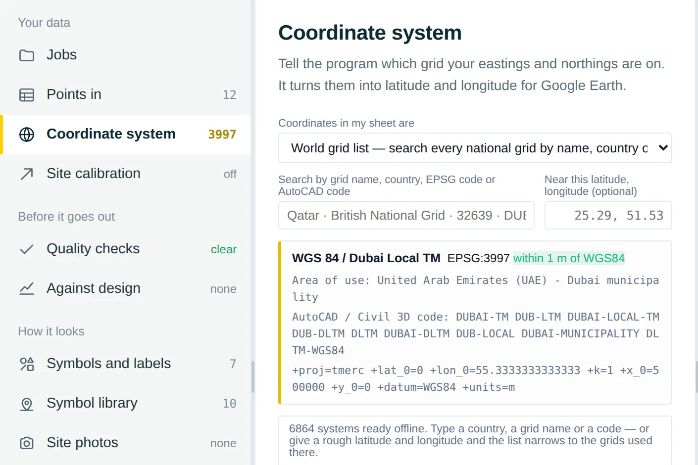
Step 2
Pick the grid your eastings and northings are on — 5,800+ systems, searchable.
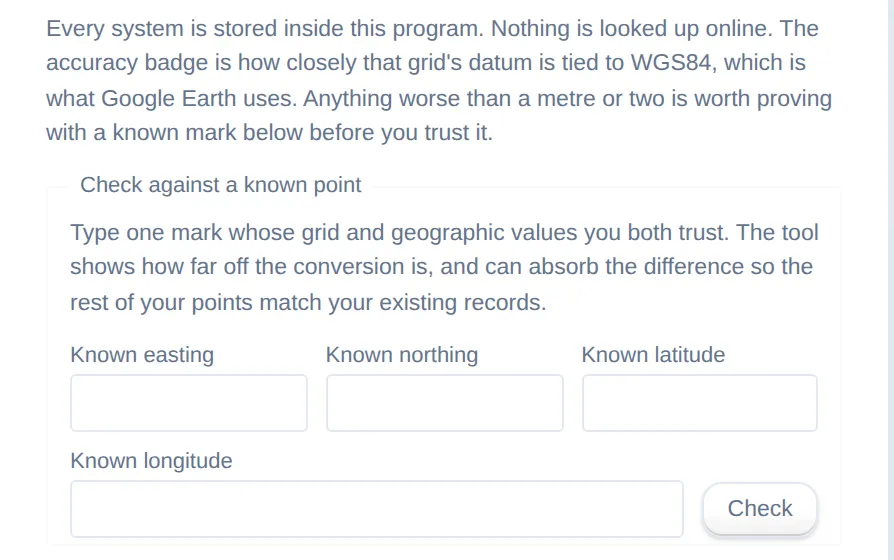
Step 3
Check one point you trust before you rely on the rest.
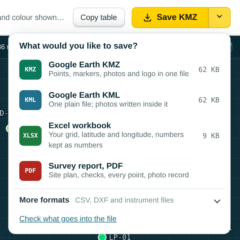
Step 4
Save KMZ with photos and logo, KML, Excel, a PDF report, CSV or DXF.
A free, fully offline survey converter. Install in under two minutes, or grab the sample dataset to try a conversion first.
Latest release
Native app for Windows 10 and 11 with 5,800+ EPSG coordinate systems, local Helmert calibration, and Google Earth 3D export built in.
Free account required · Web version available at /app
Listed with the release on GitHubGet-FileHash .\ExcelToKMLPro-Lite-Setup.exe -Algorithm SHA256Run in PowerShell from your Downloads folder — the output should match the hash above.
Three steps, under two minutes.
Click Download for Windows to get ExcelToKMLPro-Lite-Setup.exe (3.5 MB).
Double-click the file and follow the on-screen steps. The local EPSG database is configured automatically.
Open Excel to KML from the Start Menu, drop in your survey CSV or Excel sheet, pick a grid, and export 3D KML to Google Earth.
What goes in, what comes out, and the geodetic engine in between — from spreadsheet columns to Google Earth–ready KML.
Spreadsheets & field instrument exports
Google Earth–compliant deliverables
Runs entirely on your local Windows PC using the native Microsoft Edge WebView2 runtime.
Coordinates never leave your PC5,800+ projections from the official EPSG registry, transformed directly to WGS84 for Google Earth.
WGS 84 / Dubai Local TM
Qatar 1995 / QNG
WGS 84 / UTM Zone 42N
WGS 84 / UTM Zone 38N
OSGB 1936 / British National Grid
NAD83 (2011) State Plane
GDA2020 / MGA Zone 55
WGS 84 Global Ellipsoid
Every one of the 5,800+ coordinate systems has its own converter page, and short guides cover the jobs surveyors do most.
Search by name, country or EPSG code, or pick a popular grid.
Step by step, using the real buttons in the app.
Coordinate systems, spreadsheet imports, 3D exports, and data privacy — answered.
You can search by country name (like Dubai, Qatar, Pakistan, Saudi Arabia, UK) or standard EPSG number (like EPSG:3997, EPSG:2932, EPSG:32642). If you use AutoCAD Civil 3D, you can type the same drawing zone code. The tool automatically handles the math so your points land in the exact real-world spot on Google Earth.
If your site uses a local total station grid (such as a 1000, 1000 base), enter 3 or more known government control benchmarks. The software calculates scale correction and True North rotation, showing you the exact millimeter differences on each mark before exporting to Google Earth.
Yes. Field data collectors from Leica, Trimble, Topcon, and Sokkia often export comma-separated numbers without column headers. The importer lets you verify which column is Point ID, Easting, Northing, and Elevation before processing.
No. The desktop application handles 10,000+ points in under a second. You can paste large Excel sheets or drag in multi-megabyte CSV files containing entire highway traverses, cadastral boundary pegs, or topographic contour grids.
Each point is placed on Google Earth's terrain at its exact position, and its measured level appears in the balloon when you click it. The level is also kept inside the file, so it can be read back into a spreadsheet. Along a line of points you can get a level profile with chainage and grade, and the quality checks flag any level that jumps compared with its neighbours.
Yes. By grouping survey points with feature codes (like BOUNDARY, FENCE, or LOT), the software draws closed boundary outlines in Google Earth and automatically calculates boundary perimeter length and total ground area in square metres and hectares.
The conversion itself — reading your sheet, the coordinate maths and building the KML or KMZ — always runs on your own computer or in your browser. In the web app, the files you open and save are kept in your account so you can download them again from your dashboard, where you can also delete them. The Windows app sends only a short activity record (file name, number of points, coordinate system and export format), never your coordinates or photos.
Windows SmartScreen routinely shows this safety prompt on new software that isn't signed with an expensive commercial code-signing certificate yet. Click "More info" and then "Run anyway". You can also verify the official SHA-256 binary hash on GitHub.
Download Excel to KML v4.2.1 for Windows. Free to use for field surveyors, civil engineers, and GIS specialists.