Latest Release v3.5.3 • Windows 64-bit • Edge WebView2

Convert Survey Sheets to
Google Earth KML & KMZ
with Sub-Metre Precision

Turn raw CSV, total station exports, and Excel benchmark tables into rich 3D Google Earth Placemarks, boundary polygons, and geotagged photo reports. Powered by 6,864 national EPSG grids — 100% offline on your machine.

100% Offline & Private
6,864 EPSG Grids
Helmert 2D Site Fit
KMZ Photo Balloons
Excel to KML Pro — Survey Engine v3.5.3
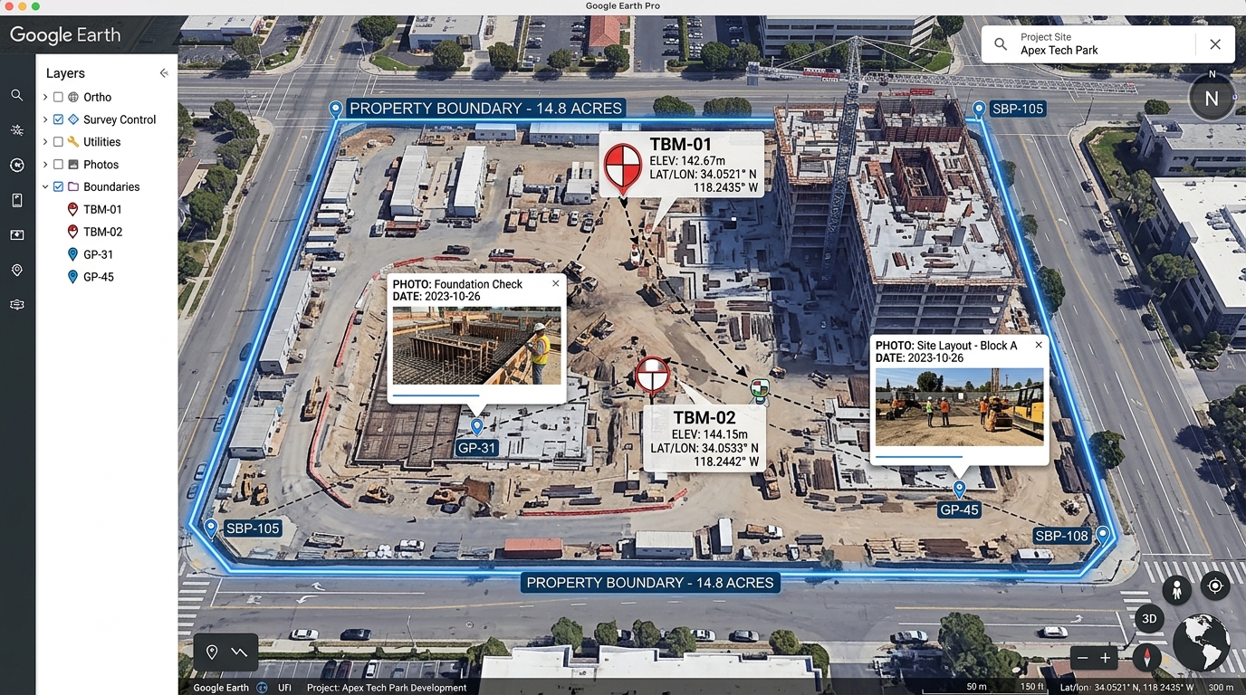
Google Earth 3D Survey Placemarks and Photo Balloons
KML / KMZ 2.2 Apex Tech Park Benchmark Project — Survey Traverses, 3D Elevation Pins & Geotagged Site Photos
Tied to WGS84 • Accuracy: < 0.05m
Digital Elevation Model and Geospatial Telemetry
EPSG:3997 DLTM Cascade North Elevation Analysis — 12 Satellites Synced • PDOP 1.1 • 6,864 World Grids Supported
Helmert 2D Helmert Fit Active
💡 Instant Testing: Edit any coordinate value above. Latitude and Longitude are calculated on-the-fly, and you can export a real Google Earth .KML immediately.
Live WGS84 Calculation
ELLIPSOID: WGS84
RADAR SIMULATION
LATITUDE (WGS84)
25.193248° N
LONGITUDE (WGS84)
55.467835° E
IDENTIFIED GRID
EPSG:3997 (Dubai DLTM)
ACCURACY BADGE
< 1m (Direct WGS84)
Open Full Tool ↗
6,864+
National Grids & EPSG Systems
3.2 MB
Ultra-Lightweight Windows Installer
100%
Offline & Secure (Zero Cloud Risk)
< 1s
Instant 10,000+ Point Conversion

Built for Cadastral Surveyors, Civil Engineers & GIS Professionals

Excel to KML Pro eliminates tedious coordinate conversion errors. Designed specifically for construction site benchmarks, infrastructure surveys, boundary traverses, and drone operations.

6,864 World Grid Systems

Search by country, EPSG code, or AutoCAD drawing code (e.g. DUB-DLTM, DUB-OLD40, OSGB36). Every projection family is supported with automated 3-parameter and 7-parameter datum shift onto WGS84.

Accuracy Badges < 1m / 1-2m Tied

100% Offline & Air-Gapped

Everything runs purely on your workstation inside the Windows Edge WebView2 engine. No survey benchmarks, defense projects, or confidential site coordinates are ever transmitted to any cloud or remote server.

Privacy Standard Air-Gapped Ready

Smart Column & Raw Importer

Paste rows straight from Excel or drag-and-drop raw total station CSV files. Automatically recognises column aliases (Easting, E, X, Level, RL, Z) or reads position-based dumps with no headers.

Auto Detection 6 Headerless Orders

Helmert 2D Site Calibration

Fit a local project site grid onto national control with multi-point least-squares calibration. Calculates shift, rotation in seconds, and scale in PPM, displaying residual errors on every control point.

Verification Known-Point Prover

KMZ Geotagged Site Photos

Attach site inspection photos matching point names or coordinate tags. Automatically bundles the pictures directly inside a portable .kmz file, displaying high-res photos inside Google Earth popup balloons.

Packaging Embedded KMZ Media

Boundary Polygons & Areas

Connect points by feature code or sequential run. Automatically closes shapes to compute exact ground perimeter length and ellipsoidal surface area in square metres (m²) and hectares (ha).

Ground Geometry m² & Hectare Areas

From Spreadsheets to Google Earth in 30 Seconds

No complicated CAD export setups or paid GIS subscriptions. Follow these 3 intuitive steps.

1

Import Survey Points

Copy and paste rows straight from Excel, drag-and-drop a CSV file, or type points by hand with auto-incrementing station IDs (TBM-01 → TBM-02).

STATION,EASTING,NORTHING,ELEV
BM-01,513556.612,2787467.856,14.85
BM-02,513642.180,2787510.320,15.22
2

Select National Grid

Type your country or AutoCAD zone code (e.g. DUB-DLTM, UTM 40N, British Grid). Check your known benchmark with the integrated prover tool.

Grid: EPSG:3997 (Dubai DLTM)
Datum: Direct WGS84 Alignment
Tie Accuracy: < 1 metre certified
3

Export 3D KML or KMZ

Press Save KML or Save KMZ. Open the generated file in Google Earth, Google Earth Pro, or GIS apps for instant 3D inspection.

Saved: W-15_Tree_Survey.kmz
Placemarks: 48 • Boundaries: 3
Photos: 12 embedded in balloon

Download Excel to KML Pro

Get the official release for Windows. Lightweight, native, and completely free to use.

RECOMMENDED Release Build: September 2026

Windows Native Installer (Lite)

Installs in seconds and uses the Microsoft Edge WebView2 display engine already built into Windows 10 and 11. Includes taskbar integration, clean window chrome, and full offline EPSG database.

Version v3.5.3
Operating System Windows 10 / 11 (64-bit)
File Size 3.14 MB (3,291,632 bytes)
License Open Source / Free
SHA-256 Checksum: Verified Binary
2ba12091e995085a9472520701c8e67d7668e6c1771499cde68b5456680429c1

In-Browser Web App

Zero Installation

Runs directly in any modern browser on macOS, Linux, ChromeOS, and Windows. Same full EPSG coordinate engine.

Launch Web Tool

Portable USB Edition

No Setup Required

Single standalone executable. Copy to a thumb drive and run directly on any field laptop without administrator privileges.

View Releases on GitHub

Android & iOS PWA

Mobile Friendly

Android APK and iOS Progressive Web App (PWA). Add to home screen in Safari or Chrome for offline surveying in the field.

Mobile Build Instructions

Technical Specifications & Compatibility

Standardized geodetic math formulas, projection definitions, and supported field instrument formats.

Category Specifications & Supported Standards
Supported Input Formats CSV (Comma-Separated) TSV (Tab-Separated) Space-Delimited TXT Direct Excel Paste Total Station Raw Exports
Auto-detects header row or position order (Point, Easting, Northing, Elevation, Code).
Supported Output Formats KML 2.2 Standard KMZ Compressed Archive Interactive HTML Survey Balloon GeoJSON Compatible Elements
Geodetic Projections Transverse Mercator, Universal Transverse Mercator (UTM 1–60 N/S), Lambert Conformal Conic (1SP & 2SP), Oblique Mercator, Cassini-Soldner, Stereographic, Krovak, Albers Equal Area, and National Custom Grids.
Ellipsoids & Datums WGS84, ETRS89, GDA94/GDA2020, NAD83, ED50, Clarke 1880, Airy 1830, Bessel 1841, Everest 1830, Hayford 1909, Qatar National Datum (QND95), DLTM, and 1,000+ local historical datums.
Datum Shift Models Automated 7-parameter Helmert (Bursa-Wolf) transformation, 3-parameter Molodensky shifts, and custom 2D site calibration from local control points.
Client Engine & Security Microsoft Edge WebView2 (Chromium 120+ based) with Go wrapper. 0 MB network egress for conversions, air-gapped security, zero external telemetry.

Answers to Common Surveyor Inquiries

Everything you need to know about coordinate accuracy, offline privacy, and file compatibility.

No, absolutely not. All coordinate parsing, projection mathematics, Helmert fitting, and KML/KMZ packaging occur 100% locally on your PC. No points or site photos are ever sent over a network. The only optional feature that touches the internet is the "Load Satellite" toggle on the map preview if you choose to turn it on.
Windows SmartScreen warns about any newly released or open-source executable that does not have an expensive commercial digital certificate ($400+/year). This is completely normal for community open-source software. Simply click "More info" and then "Run anyway". You can verify the official SHA-256 hash or review the open-source code on GitHub.
In AutoCAD Civil 3D, check your Drawing Settings under Units and Zone. For example, DUB-DLTM is Dubai Local Transverse Mercator (EPSG:3997), and DUB-OLD40 is Old Dubai on UTM Zone 40 (EPSG:27040). You can type those exact CAD codes straight into the grid search box in Excel to KML Pro, and a yellow CAD badge will confirm the match.
Yes. Raw exports from total stations (Leica, Trimble, Topcon, Sokkia) frequently contain only numbers. Excel to KML Pro automatically identifies that no headers exist and reads the columns by position. A yellow bar appears displaying the assumed column order, allowing you to select between 6 different orders (e.g., Station-Easting-Northing-Elevation or Point-Northing-Easting).
When you enter 3 or more known control benchmark coordinates, the calibration engine solves the best transformation parameters: Translation (X and Y shifts), Rotation (in seconds of arc), and Scale factor (in PPM). It highlights residual errors on each mark so you can instantly detect if a physical survey peg has been disturbed or mismeasured.
The Lite build (3.2 MB) uses the Edge WebView2 engine already pre-installed in Windows 10 and 11, resulting in a tiny download and instantaneous startup. The heavy Electron build (~62 MB) includes its own Chromium rendering engine and is only needed if running on an outdated or stripped-down Windows installation lacking WebView2.

Start Converting Your Survey Files Today

Download Excel to KML Pro (v3.5.3) for Windows or try the full web app directly in your browser. Fast, accurate, and completely free.

Download for Windows (3.14 MB) Launch Web App